
Guidebooks Updates & Errata Page
Listed below are some of the main errors and significant updates that have been discovered in my guidebook to the Andes. This is just a short list of actual mistakes and major changes. In towns and cities new shops open up and old ones close, and everything gets more expensive - these type of changes will be incorporated in the next editions of the books. Basic, obvious, grammar and spelling mistakes are not listed, unless they will interfere with understanding
The Andes - A Guide for Climbers & Skiers - 5th Edition (Paperback & E-book)
The Andes - A Guide for Climbers - 4th edition (Paperback)
The Andes - A Guide for Climbers - 5th Edition
Paperback ISBN 978-0-9536087-6-8
e-ISBN 978-0-9536087-7-5
Errata for the 5th edition will be added here when they are discovered. The paper guidebook was published in February 2020, the E-book in June 2021.
p. 7 - In the table of grades, the 6th entry down in the "French" column should read 5+
p. 88 - Huascarán Sur. A new survey recently seen by the author suggests the height may be 6757m, this would make it the 5th highest in the Andes (paper edition only).
p.178 - Uturunco - A local guide is now a requirement due to this mountain being in a national park.
p.180 - Arequipa - Carlos Zarate's office has moved to Jerusalen 260.
p.232 - Fiambalá. After 25 years Jonson Reynosos office has moved. He's now in the radio station FM Fiambalá, about 100m further N on the main street. Ruth no longer runs a hostel. A permit (free) may now be required, but can be obtained online, initially thru Turismo Catamarca.
p. 234 - El Fraile Climb. 3rd/4th line. Should read "from a high camp at about 5000-5100m on the NE side in Chile". Not NW (paper edition only).
p. 246 - Colangüil. The best start is located between the two described starts, where a short spur track leads W for 1½km from near the main "road" to a 3450m high point above the south side of the Rio Lavadero
.
p.252 - Mountain Info in Mendoza. Line 16. The Orviz address should be J.B. Justo 532 (as correctly stated lower down on the same page (paper edition only).
p.333 - Bonete Norte I (Pioneros). I have new information that this peak was climbed by an Italian/Argentine group in 2002.
The Andes - A Guide for Climbers - 4th Edition
Paperback ISBN 978-0-9536087-4-4
Errata for the 4th edition will be added here when they are discovered. The guidebook was published in March 2015.
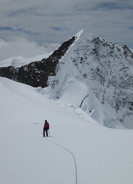
p. 41 -- Pico Colon -- This peak has been notoriously hard to get permission to ascend for many years. However it was climbed by the author in December 2015. The approach was from Palmor to the west and took 6 days, with a couple of days to climb the peak and four days to walk back out. The ascent itself was made by the NW glacier couloir to the La Horqueta col and then easily up the SW ridge. Grade for Colon was PD, with a 60m pitch of 45º snow to gain the col. Bolivar looked quite a bit harder, certainly AD and with a lot of steep exposed snow. The summit height of Colon was c.5730m on the GPS. Bolivar is probably the same height plus or minus a few metres only. The picture below shows Pico Bolivar from just below the summit of Pico Colon.
p.80 -- The main Caraz peak, Oeste, was downsized to c.5980m following photographic studies (also the lack of a 6000m contour on the PIGM maps). It's height is 6025m on the DAV map. Caraz Este is a lower peak, so it's height should be about 5975m (not 6020m as stated).
Solimana -- A better start is from the new road (easy 4x4) to the N of the peak, parking at 15º19'46" 72º54'05"
p.182 & 183 -- Hualca Hualca -- the grade to the summit is just F in most conditions.
p.186 -- CHACHANI -- A new route up the N slopes is now more commonly used, and will certainly be better if there is much snow on the peak. Drive to a 4x4 base camp at 5050m in a col N of the peak, from here walk W (almost level) for 1½h. to an advance base camp beneath the N side of the peak. Then easily up a good zig-zag footpath to the summit, normally only a little snow at 5900m+. KEY WAYPOINTS Parking 16º10'03" 71º30'45" Advance Base 16º10'38" 71º31'52" 5800m 16º11'21" 71º32'10" Summit 16º11'43" 71º31'55"
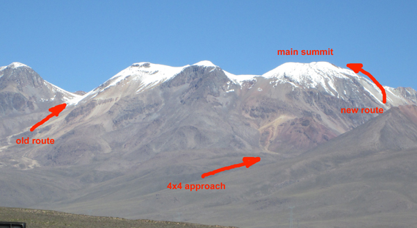
This diagram shows Chachani from the North, and the new route on the NW slopes.
There are more photos of the new route on our Chachani information page
p.188 -- Pichu Pichu -- there is now a 4x4 track down the east side of the peak to a small parking area at 4580m at 16º25'23" 71º12'36"
p.221 -- Puntiagudo -- the height should read 5940m.
p. 249 -- Aconcagua -- The permit system has changed slightly again. There are more or less the same requirements as before, but you now have to go through one of 8 or 10 approved operators to obtain your permit. The cost in the 2015-16 season was $720 to $945, low or high season.
p.314 -- It was of course Maestri who made the claims about the first ascent of Cerro Torre, Toni Egger unfortunately died on the mountain.
p.329 -- The Next Ten -- Tocllaraju c.5980m and Caraz c.5980m should be in this list, at least if their newly estimated (lower) heights are correct. See above for more details.
